

Hottest June on record looms as experts explain July heat
30 June 2026
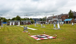
Meteorologists at the University of Reading have recorded Reading’s hottest June since records began in 1908.
The average temperature recorded at the Reading University Atmospheric Observatory in June 2026 was 18.75°C, surpassing the mean temperature of 18.31°C recorded in June 2025.
Dr Stephen Burt and Dr Ben Harvey, University of Reading, outline the records broken last week, and explain why temperatures are set to rise again next week. For interviews, contact the University of Reading Press Office on 0118 378 5757 or pressoffice@reading.ac.uk.
Extra resources:
-
Stats from Reading’s record June heatwave have been summarised and explained in a new website created by Dr Kieran Hunt.
-
Find out how extra hot your area is: istheukhotrightnow.com/
Dr Stephen Burt, Department of Meteorology, University of Reading, said: "Last week served up something the record books have never seen before. Four consecutive days with temperatures reaching 34 °C is a new extreme for any month of the year. Until now, the longest we'd endured at or above this level was just two days, in July 1923, August 2003, August 2020 and July 2022. Even the legendary summer of 1976 only managed three days in a row above 33 °C, from the 26th to the 28th of June. To string four such days together is genuinely uncharted territory.
"There was no respite after dark. Night-time temperatures stayed stubbornly, almost oppressively high right through the final week of June. From Monday the 22nd to Sunday the 28th, seven nights in a row, the temperature simply refused to drop below 17 °C. That comfortably beats the previous record for any month, four consecutive nights above 17 °C, set in July 1923, August 1997, August 2020 and August 2022. It's the kind of relentless warmth that leaves little chance to cool down and recover before the next day's heat arrives."
Other notable records include:
-
The hottest day was Wednesday 24 June, with a maximum temperature of 34.9 °C. This was a new June record temperature for Reading, surpassing the previous record of 34.0 °C set on 26 June 1976. The 1976 record had first been exceeded the previous day, Tuesday 23rd, when the maximum temperature reached 34.1 °C.
-
Friday 26 June saw the highest 24-hour minimum temperature on record at 21.3 °C, making this Reading's hottest night on record. The previous warmest June night was 18.9 °C, on 29 June 1949, meaning the record was beaten by more than two degrees.
-
Since records began in 1908, it was over 40 years before the first 'tropical night' in Reading, with a minimum temperature higher than 20°C, in September 1949. It was almost 30 years before the second instance, on 2 August 1995. Since then, Reading has recorded tropical nights in August 2020, July 2022 (twice), July 2025, and now twice in the past week.
A hot July?
As the heatwave fades, temperatures are expected to surpass 30 °C again next week, according to Met Office forecasts.
Dr Ben Harvey, senior research scientist at the University of Reading, explains the difference between last week’s heatwave and the forecast for a hot spell in July.
He said: “Last week, a slow-moving area of low pressure known as a 'cut-off' low became stranded off the coast of Portugal and tapped into the very warm air mass over north Africa, bringing it northward over western Europe. This setup is not in itself exceptional, but the length of time it persisted was unusual and its positioning was just right to impact France and the UK. It led to the record-shattering temperatures observed, with our warming climate making its ever-present contribution.
“So far, the forecasts for next week are different. A more typical ridging scenario is expected, with high pressure, clear skies and warm temperatures but, crucially, not the cut-off low dragging up the really hot and humid air from the south. So while a heatwave is forecast, and its impacts will be heightened due to following a very hot period, the synoptic situation is currently suggesting slightly lower temperatures overall and potentially also more stable forecasts. But as always with forecasts a week ahead, the details will change as we get closer. I'd encourage people to keep checking the latest forecasts rather than relying on what's predicted now, and to take any weather warnings seriously when they're issued. These warnings exist to help people prepare, whether that means staying hydrated, checking on elderly neighbours or adjusting plans to avoid the peak heat."
Loading additional items please wait....
mask