| The Silchester Town Life project |
| Contents
Victorian Excavation Methodology Late and Post-Roman Archaeology
|
Insula
IX
 |
Why Insula IX?
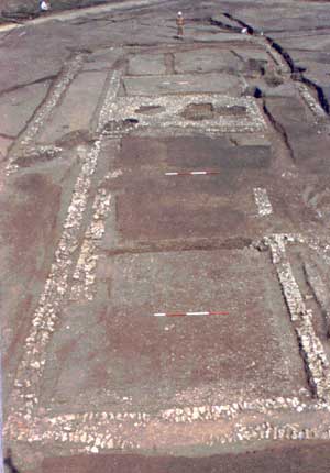
The choice of Insula IX was determined by a number of factors. Recent
aerial photography and geophysical survey work had shown that more buildings
existed here than had been originally identified by the Victorian excavators
in 1893. There were also apparently blank areas devoid of buildings,
where neither the excavation of 1893 nor subsequent aerial prospection
had revealed structural remains. Excavating nearly one-third of Insula
IX, in the heart of the Roman town, could offer the opportunity to see
if these 'blank' areas contained timber buildings, as well as providing
vital new information about earlier buildings, or phases of buildings,
and the Iron Age origins of the town. In addition to one town house which,
unusually, lies diagonally across the Insula, this part of the Roman town
was also thought to contain shops and workshop properties fronting on to
the main north-south street. The possibility also existed that excavation
could provide new information about why Silchester, unlike comparable Roman
cities such as London, Winchester and Chichester, never re-emerged as a
town in the later Anglo-Saxon period.
Interim Reports are available on each season of the excavation so far
- 1997
excavation, the 1998
excavation and the 1999 excavation
. A brief summary of the findings is given below.
Late and post-Roman archaeology:
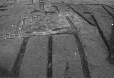
Following the abandonment and robbing in the mid-to-late third century
of the large, aisled town house which lies at some 45 degrees to the Roman
street grid, the insula was divided into a number of rectangular plots
occupied by buildings fronting onto the streets. The plots behind
the buildings are defined by rows of post-holes or pits. At least
five buildings occupied the frontage of the north-south street with occupation
continuing down to the end of the fourth or into the early fifth century.
These buildings ranged from substantial stone-built two-storeyed constructions
located towards the southern end of the street, to timber framed buildings
of post-built construction at the northern junction with the east-west
street.
A large hearth with abundant traces of iron-forging residues is associated
with the property on the street corner. Traces of a possible cupellation
hearth were found cutting the floor make-up at the north-east end of the
destroyed diagonal house, suggesting that precious metalworking was also
being carried out in this part of the town.
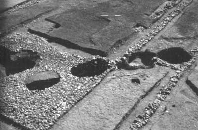
Behind the buildings the plots contained wells and rubbish pits which
have produced evidence not only for late Roman diet, but also for various
commercial activities such as the slaughtering of animals for meat products.
Deliberate burial of whole pots and entire animal skeletons, in particular
dogs, in many of these pits and wells may be evidence for Late Roman ritual
activity. Amongst these late Roman features lies the shallow well from
which was recovered in 1893 the stone with the inscription in ogham, a
form of Celtic writing. Recovery of wood from the very bottom of this well
has produced two radiocarbon dates, the later of which is 1630+/- 45BP,
which gives a calibrated date of AD 360-530 at 68% confidence, or 320-540
at 97% confidence.
Pit alignments
 |
Late Iron Age
One of the wells excavated in 1893 close to the east-west street at
the north end of the excavation appears on re-excavation to have originated
in the late Iron Age.
Objectives for 2003
It is intended that we will further clarify the 2nd century AD occupation
of the site, as well as taking the opportunity of beginning to understand
the layout of the 1st century early Roman town. There will be a continued
emphasis on the early Roman (mid 1st century AD - early 3rd century AD)
occupation of the site and the recording and removal of the extensive
layer of silt in the south-east quarter of the excavation will reveal
the remains of at least two 1st/2nd century AD structures on a similar
alignment to House 1. Gradually the layout of the early Roman town of
Silchester is emerging. There will be the excavation of two further 2nd
century AD wells on the eastern half of the excavation and the recording
and examination of the two 1st century AD stone buildings on the site
of House 1. In 2003, we will begin to clarify and reveal the 2nd century
AD occupation along the east-west street frontage and continue to excavate
the street surfaces.
To find out about the 2002 season in Insula IX of Silchester, please go to our Silchester 2002 page which was updated weekly during the excavation season.
|
Silchester
Home | Archaeology
Home | Reading
Home © 2002 Reading University Archaeology Department.
|