Forecasters look higher to make better cold weather predictions
Release Date 17 January 2013

As Britain shivers through another spell of snow and ice, new research could help weather forecasters predict when such cold snaps are likely to occur.
Professor Ted Shepherd, an expert on the stratosphere at the University of Reading, is co-author of a research paper published this week that helps to confirm the value of studying what's going on high up in the atmosphere to help predict the weather we are likely to see at the surface.
Weather forecasts mainly focus on the troposphere - the lower layers of the atmosphere from the earth's surface up to around 10km - as that is where most of our weather comes from.
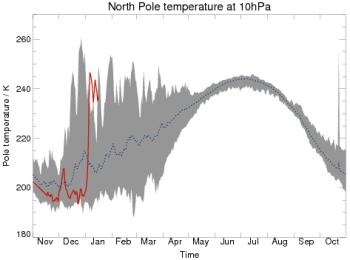
However, scientists are increasingly learning that changes to the upper layers of the atmosphere, such as the stratosphere, can have a significant effect on our weather. In a paper published in Nature Geoscience, Professor Shepherd, working with colleagues in Toronto, Canada, where he worked prior to coming to Reading, found evidence that detecting sudden increases in temperatures, high up over the Arctic, was a good indicator that people in Britain and northern Europe could paradoxically expect a big freeze.
The researchers found that these 'stratospheric sudden warming' events were more helpful than had previously been thought in helping forecasters provide better winter forecasts, and could help to predict a cold snap in Britain and northern Europe several weeks ahead.
Professor Shepherd said: "It is well known that stratospheric sudden warming events can affect weather for a period of up to two months.
"The seasonal forecasts issued recently by a number of weather centres predict that Britain will be about 1 degree centigrade colder than average through to the end of February. That might not sound like a lot but averaged over a month it makes quite a difference.
"Our research has shown how a sudden warming high in the stratosphere can add extra skill to wintertime seasonal forecasting - which, evidence shows, had previously been very difficult to get right. Our work shows that we can have more confidence in seasonal winter predictions when these high atmosphere warming events occur."
ENDS
For more information contact Pete Castle or Donna Sibley at the University of Reading press office on 0118 378 7391 or p.castle@reading.ac.uk or d.l.sibley@reading.ac.uk.
Notes to editors:
M. Sigmond, J. F. Scinocca, V. V. Kharin & T. G. Shepherd (2013) ‘Enhanced seasonal forecast skill following stratospheric sudden warmings', Nature Geoscience (2013) doi:10.1038/ngeo1698, available online at: http://www.nature.com/ngeo/journal/vaop/ncurrent/full/ngeo1698.html
The University of Reading is ranked among the top 1% of universities in the world (THE World University Rankings 2012).
Its Department of Meteorology is internationally renowned for its excellent teaching and research in atmospheric, oceanic and climate science. Established in 1965, Reading is the only UK university which offers a full range of undergraduate and postgraduate courses in meteorology. The University of Reading is world-renowned for its pioneering research on weather, climate and earth observation and is also home to the Walker Institute for Climate System Research.